
This page was produced with the assistance and advice of the Digital and Physical Mapping Intern Carmel Allinson (Undergraduate Lancaster)

As Community Members you have access to the maps space. This space is on A floor in the Library, to the left of the Library tree.
The space has 7 cabinets with local and regional maps, along with key world maps and geological maps. Many of the cabinets contain large print historical Ordinance Survey maps, but they also contain reprints of classic maps, and Lancaster urban town planning maps.
You are permitted to take images of maps in the space, using cameras or mobile phones, for personal or planning dispute use, but please be aware that copyright concerning maps can be complex so do not distribute these images without permission. Fortunately many of our most popular maps are available on this Guide, in a high resolution.
Ordnance Survey Maps
A range of Ordnance Survey maps of Lancashire are available in cabinets at various scales. These include the 1840's first edition of the six-inch maps, facsimile copies of the first edition one-inch maps, and copies of modern maps at scales from 1:250,000 to 1:2,500. For online access we would recommend the National Library of Scotland for browsable OS maps.
Recommended Historical Street Plans of Lancaster (Located in Map Cabinet 'Plans of Lancaster and Morecambe')
The earliest and most well known map in our collection is the John Speed Plan of Lancaster, surveyed in 1607. Speed's maps were unequalled during the early Elizabethan era and this was the first map to depict Lancaster and its layout in any detail. It is commonly seen as an inset in other maps such as the Binns map of 1821. It is available as Duplicate in the Maps Cabinets, and also available in an Atlas in the Maps Area.
The original is held by Lancaster County Council, and Merton College Oxford and further reading about the significance of this map can be found at the Lancaster Archaeological and Historical Society article John Speeds Town Plan of Lancaster in 1607.
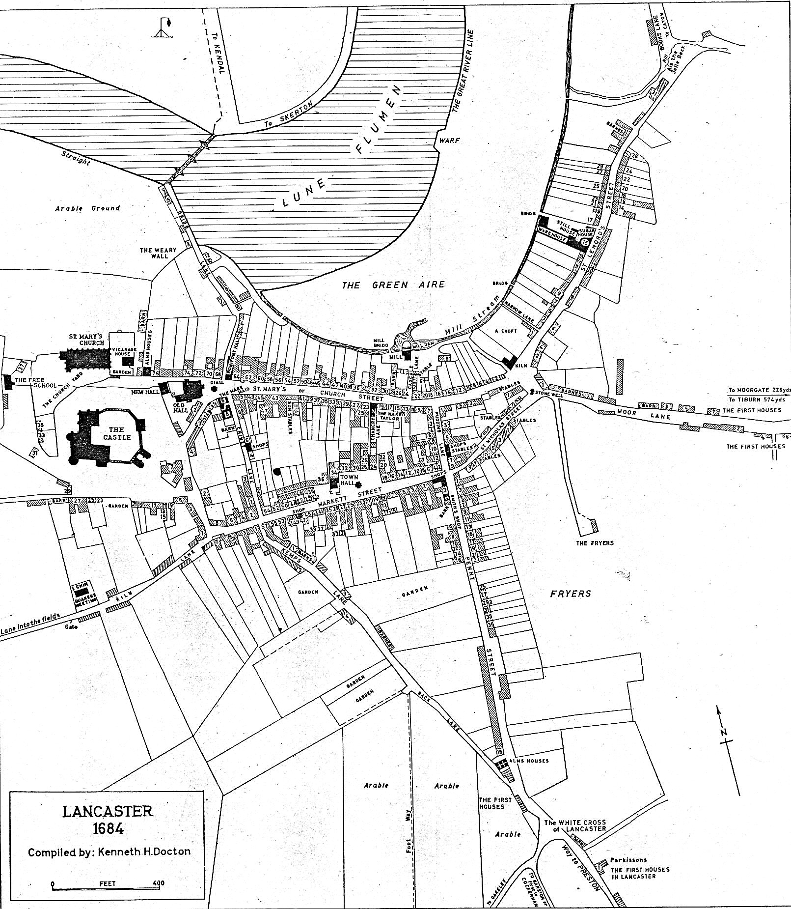
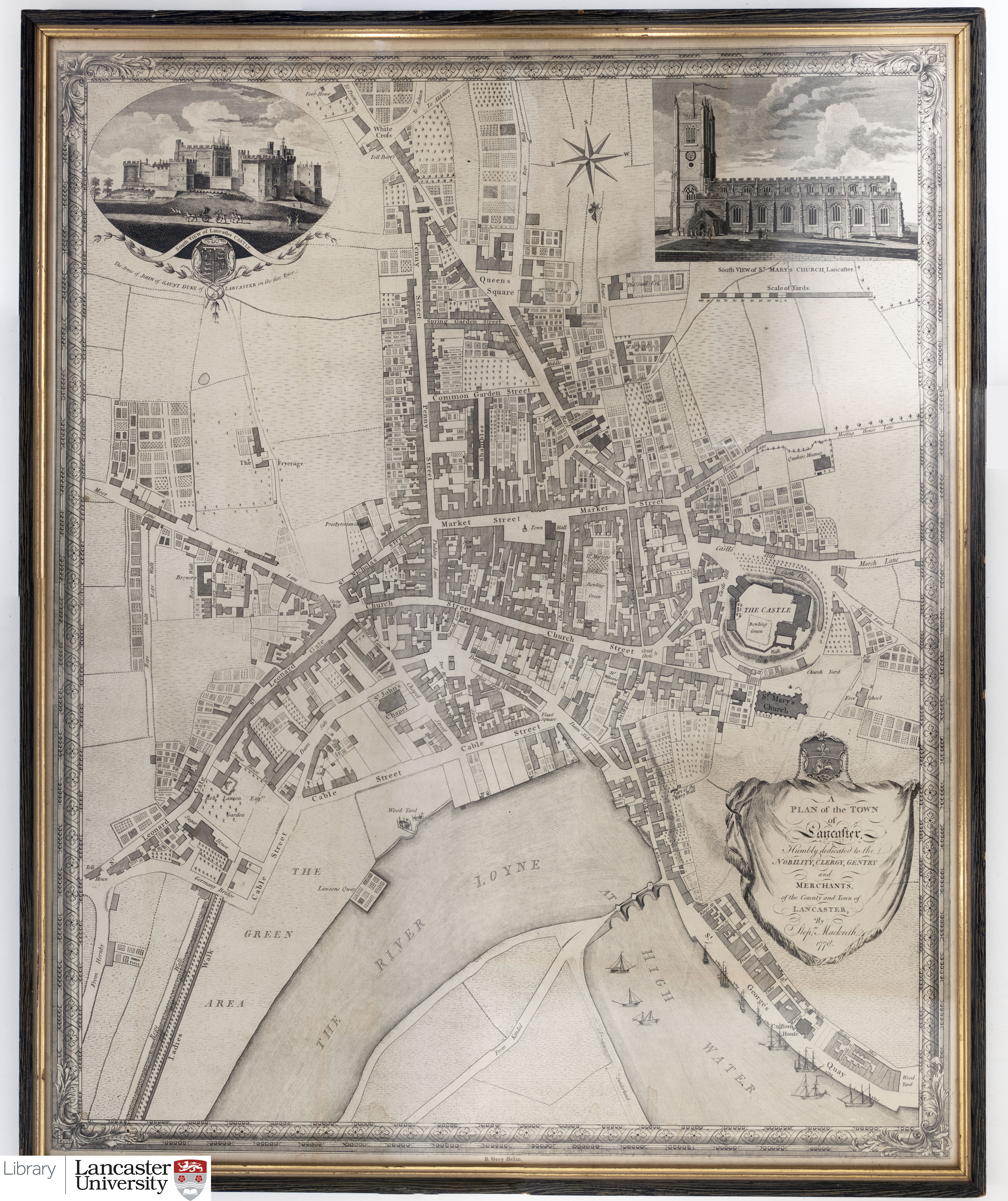
We also hold a reproduction of the Kenneth Docton Reconstruction of Lancaster based on Richard Kuerden's 1684 survey in the Maps Cabinets, courtesy of the Historic Society of Lancashire and Cheshire, as well as an original and facsimile versions of Mackreth's 1778 Plan of the Town of Lancaster. Note that this map positions south at the top. These three early town plans (Speed, Docton, Mackreth) are discussed by Ian James Saunders in The Earliest Surveying of the Town of Lancaster.
Further reading on Mackreth's map can also be found from the article Mackreth's Map of Lancaster, 1778.
 A Lancaster Museum reprint of Clark's 1807 Plan of the Town of Lancaster is available in the Map Cabinets. Several sites for the expansion of Lancaster are indicated here, including 'intended streets', an 'intended square' and an 'intended quay'. However, many of these sites remained undeveloped, such as the street labelled Duncan Wharf near Dalton Square, which was never built. When compared to other plans of the time the map appears to contain inaccuracies is generally considered to be representative rather than a true survey of the town at the time.
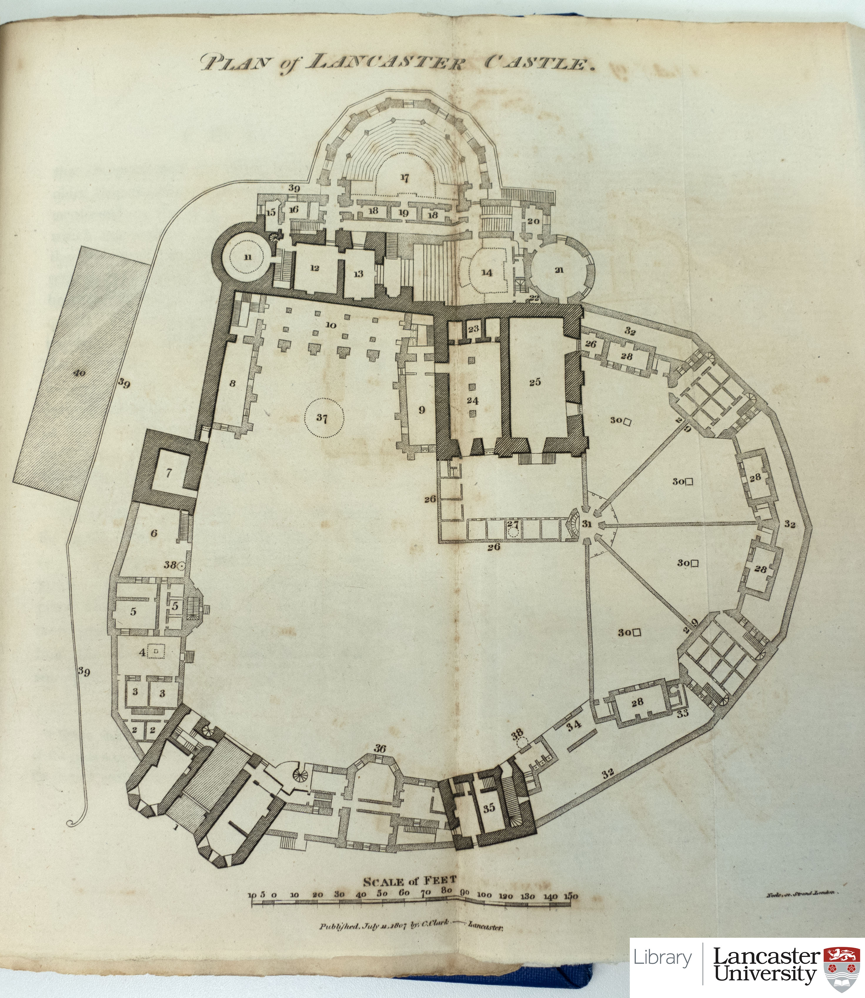
This is one of the earliest maps to depict the Lancaster Canal, which opened in 1797 and was included in Clark's 1807 book, 'An historical and descriptive account of the town of Lancaster', which Lancaster University Library holds within Special Collections. The same book contained Clark's Plan of Lancaster Castle.
Jonathan Binns' 1821 Map of the town and castle of Lancaster is held as both an original and as reproductions, which can be found in the Map Cabinets. This map includes an inset of Speed's aforementioned 1607 plan, as well as insets of the view of Lancaster from the north east and of Lancaster Castle. The town is mapped in great detail and artistic flair, showing the designs of individual gardens and buildings.
Edward Baines' Plan of Lancaster from 1824 is held as a physical version in Special Collections. This map positions west at the top and although not as detailed as Binns' map, it contains an engraving of Lancaster Castle as well as the 'Arms of Lancaster'. It was published in the book 'Baines' history, directory and gazetteer of the county palatine of Lancaster' which is also a useful resource for tracing old family members.
A Key to the Scenery surrounding Morecambe Bay, 1850 by Robert B. Peacock is a particularly interesting map held in Special Collections. Stretching from Black Combe to the Howgill Fells, it depicts a panoramic view of the mountains and lakes visible from the perspective of what is now Morecambe. Features are labelled with their name, county, height and distance and bearing from Poulton.

We hold in our collection a reproduction of Gorton's 1864 map 'A New Plan of Poulton and Morecambe'. This is of note because Morecambe did not officially adopt its name until 1889, although the name Morecambe Bay appears on maps since 1774. This map is one of the earliest street plans of the area and is available in the Map Cabinets. We do not hold the original, and believe this is held with Lancaster County Council.
Recommended Historical County Maps of Lancashire
 A reproduction of Christopher Saxton's 'Lancastriae comitatus palatin' is available within the Map Cabinet 'Lancashire County Maps'. Surveyed in 1577, this is the first printed map of Lancashire. It was produced for Saxton's 'Atlas of England and Wales', published in 1579 with the support of Queen Elizabeth I and the first national atlas of its kind. Engravings include sea monsters and coats of arms. This map has been reproduced in several books, including in Camden' 'Britannia' (1610), engraved by W. Hole.
An original of this map is held in Special Collections. The accuracy of Saxton's maps were such that they continued to be in use with revisions throughout the 17th and 18th centuries until the publishing of the Ordnance Survey's series of one inch maps.
Gerard Mercator is one of the most renowned cartographers of all time with his most famous work being the 'Mercator Projection'. In Special Collections we hold an original of Mercator's map of 'Westmorlandia Lancastria Cestria Caernarvan Denbigh, Flint Merionidh, Montgomery Sa Lopia Cum Insulis Mania Et Anglesey', circa 1620. This depicts part of the coast of north west England and Wales as well as the Isle of Man. Heysham, Lancaster and Preston are shown, as is a sea monster.
 An original of M. Mackenzie Senior's 1775 map depicting 'Part of the West Coast of England from Formby Point to Walney I' is held in Special Collections. Positioning east at the top of the map, the bay and estuaries are detailed with information on their tidal patterns, e.g. 'Dry at 4 Hours Ebb'. Settlements and their relative sizes are indicated by the number and type of buildings, including Lancaster Castle.
Published in 1836, J. & C. Walker's map depicts Lancashire as it was in 1086 according to the Doomsday Survey. Several place names have different spellings to their modern-day equivalents, e.g. Lancaster is 'Loncastre', Preston is 'Prestune' and Heysham is 'Hessam'. Poulton, Bare and Torrisholme are all indicated, although didn't officially merge to form what is now Morecambe until 1889.
 The largest and most detailed map of Lancashire in the collection is that by G. Hennet, published by Henry Teesdale in 1830. It includes an engraving of the new Custom House in Liverpool, which was part of Lancashire at the time. A physical version of this map is held in Special Collections.
A selection of other maps of Lancashire that have not been digitised are available in the Map Cabinet 'Lancashire County Maps'. The National Library of Scotland also has a collection of Lancashire county maps available to view online.
Useful information is also available in:
Bagley, J.J. Lancashire: a history of the county palatine in early maps.
Penney, S.H. Lancaster: the evolution of its townscape to 1800.
A range of additional free online maps and mapping resources are linked on the page Maps online.
Lancaster University Students and Staff can also access Digimap and Earthblox.io.
We have a guide for School aged children, highlighting interesting maps from our collection at Maps for Schools.
Maps of Lancashire and Lancaster, along with local data can be accessed via MARIO (Maps & Related Information Online) from Lancashire County Council.