Maps available from the Lancaster University Library collection attract different copyright terms, which will be highlighted wherever possible.
Many maps are available under a Creative Commons (CC BY 4.0) licence where highlighted to allow easy reuse. If this licence does not suit your particular use, please contact the library.
You can use our maps on Blogs, Social Networking or even Commercial Products, but always credit Lancaster University Library.

The following maps have been scanned from the Lancaster University Library Map Collection (unless otherwise stated). The jpeg images may be reduced to fit the screen and can usually be enlarged, depending on your browser. The library is able to provide uncompressed original digital files, upon request.
Warning: File sizes for some maps are large, and may download slowly especially on mobile connections. If you right click on the image, and click 'Save Link As' you can save the map and open it in a desktop image viewer, rather than browser, for easier zooming in on details on slower computers.
Note: This area was not officially named Morecambe until 1889, so does not appear on maps before this date. The hamlets of Poulton, Bare and Torrisholme which eventually became what is now Morecambe may be noted instead.
| Year | Name | Image | Attribution |
| 1844/45 |
Ordnance Survey 6 inch map. 1st edition. (Sheet 30.) Published 1848. |
 |
Reproduced from 1848 Ordnance Survey® map Available via DigiMaps (University Staff and Students) or National Library of Scotland (Public) |
| 1850 | Robert B. Peacock. A Key to the Scenery surrounding Morecambe Bay, extending from Blackcombe in Cumberland to Howgill Fells in Yorkshire, as seen from Poulton-le-Sands near Lancaster. |  |
CC BY-SA 4.0 |
| 1864 | Gorton. A New Plan of Poulton and Morecambe. |  |
Available only as a physical reproduction, located in map cabinet 'Plans of Lancaster and Morecambe' |
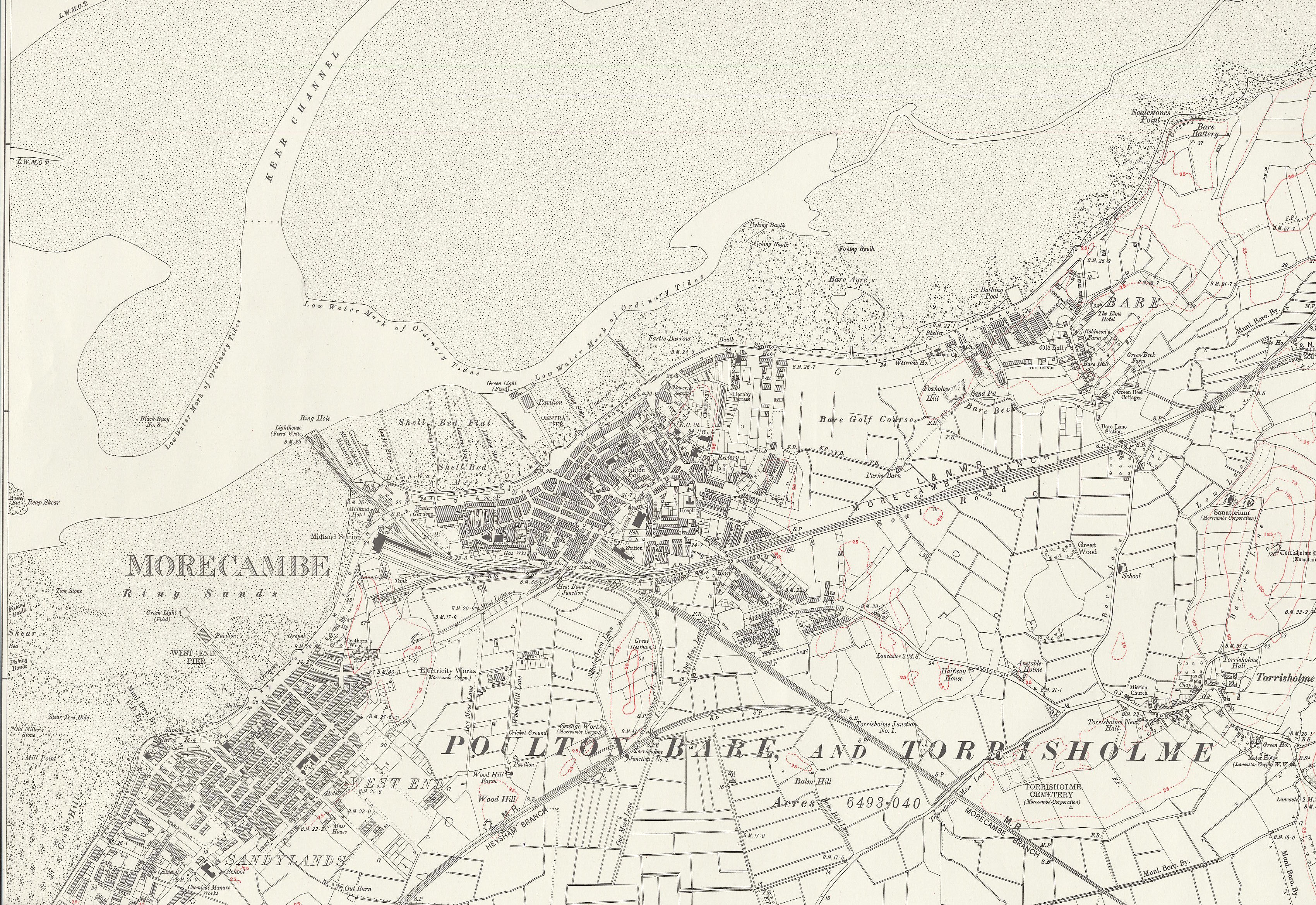
| 1891 survey |
Ordnance Survey 6 inch map. 1st revision. (Sheet XXX.) Published 1895. |
 |
Reproduced from 1895 Ordnance Survey® map Available via DigiMaps (University Staff and Students) or National Library of Scotland (Public) |
| 1891 | Morecambe, West End and Sandylands. Ordnance Survey 25 inch map. (Sheet XXX 5) |  |
See website |
| 1891 | Bare. Ordnance Survey 25 inch map. (Sheet XXX 2) |  |
See website |
| 1891 | Torrisholme. Ordnance Survey 25 inch map. (Sheet XXX 6) |  |
See website |
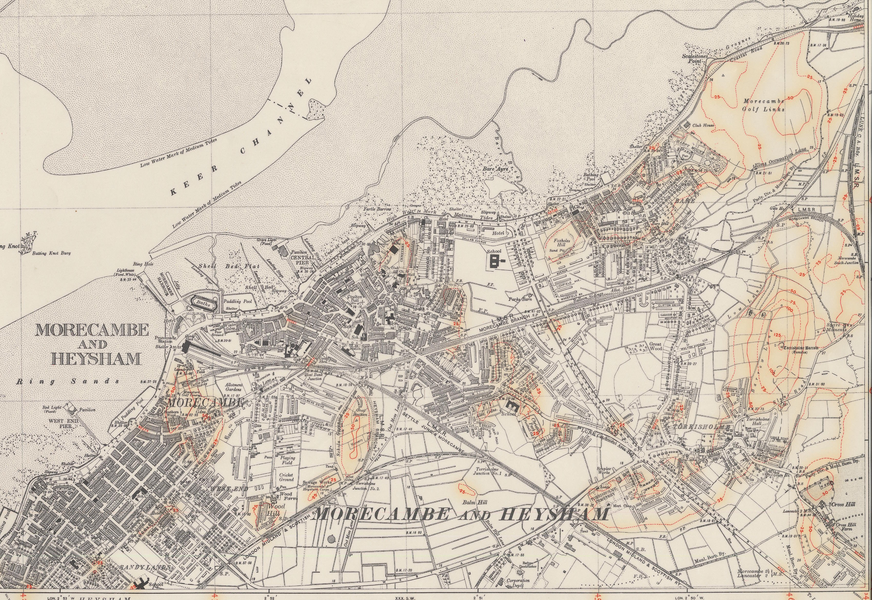
| 1911 survey |
Ordnance Survey 6 inch map. (Sheet XXX NW) Published 1919. |
 |
Reproduced from 1919 Ordnance Survey® map Available via DigiMaps (University Staff and Students) or National Library of Scotland (Public) |
| 1913 | Morecambe, West End and Sandylands. Ordnance Survey 25 inch map. (Sheet XXX 5) |  |
See website |
| 1913 | Bare. Ordnance Survey 25 inch map. (Sheet XXX 2) |  |
See website |
| 1913 | Torrisholme. Ordnance Survey 25 inch map. (Sheet XXX 6) |  |
See website |
| 1913 | Lower Heysham. Ordnance Survey 25 inch map. (Sheet XXIX 12) |  |
See website |
| 1933 | Morecambe, West End and Sandylands. Ordnance Survey 25 inch map. (Sheet XXX 5) |  |
See website |
| 1933 | Bare. Ordnance Survey 25 inch map. (Sheet XXX 2) |  |
See website |
| 1933 | Torrisholme. Ordnance Survey 25 inch map. (Sheet XXX 6) |  |
See website |
| 1937 | Morecambe, West End and Sandylands. Ordnance Survey 25 inch map. (Sheet XXX 5) |  |
See website |
| 1937 | Bare. Ordnance Survey 25 inch map. (Sheet XXX 2) |  |
See website |
| 1937 | Torrisholme. Ordnance Survey 25 inch map. (Sheet XXX 6) |  |
See website |
| 1931 survey revised, additions in 1937 & 1938 |
Ordnance Survey 6 inch map. (Sheet XXX NW) Provisional Edition |
 |
Reproduced from 1938 Ordnance Survey® map Available via DigiMaps (University Staff and Students) or National Library of Scotland (Public) |